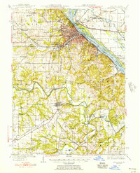
1936 Map of Hannibal
USGS Topo · Published 1956About this map
Hannibal serves as the focal point of this mid-century riverfront study, where the Mississippi River defines the border between Missouri and Illinois. The landscape is marked by the legacy of its most famous resident, seen in the Mark Twain Memorial Bridge and the Mark Twain Cave south of the city. Significant educational and social landmarks like Hannibal La Grange College and the Hannibal Country Club are situated among the hills overlooking the river valley. To the south, New London anchors the Salt River valley, a region dominated by small rural school districts and family cemeteries like Maupin Cem and Bethel Cem. The transport network shows a bustling rail era with the Chicago Burlington and Quincy RR and Wabash RR converging at this vital river crossing.
Find a feature on this map
91 named features on this map. Tap any name to fly to it.
Don’t see what you’re looking for? This feature index may not catch every label — zoom into the map to look around manually.
Map Details
Editions of this 1936 Hannibal Map
2 editions found
Other maps of this area

1890 · Louisiana
USGS Topo · 1:125,000

1890 · Mexico
USGS Topo · 1:125,000

1903 · Palmyra
USGS Topo · 1:125,000

1925 · Quincy
USGS Topo · 1:62,500

1925 · Liberty
USGS Topo · 1:62,500

1927 · Liberty
USGS Topo · 1:62,500

1931 · Barry
USGS Topo · 1:62,500

1932 · Hannibal
USGS Topo · 1:62,500

1936 · Hannibal
USGS Topo · 1:48,000

1936 · Barry
USGS Topo · 1:48,000