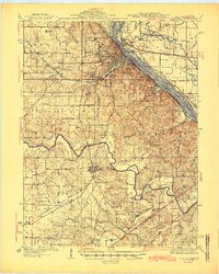
1945 Map of Hannibal
USGS Topo · Published 1945About this map
Hannibal serves as the focal point of this mid-1940s survey, where the Mississippi River creates a natural border between Missouri and Illinois. The city is a hub of transportation, shown at a time when the Mark Twain Memorial Bridge and several railroads, including the Wabash RR and the Burlington Route, converged on the riverfront. Notable literary and local landmarks like the Mark Twain Cave and the Hannibal Country Club are documented alongside the town's expanding footprint.
Find a feature on this map
104 named features on this map. Tap any name to fly to it.
Don’t see what you’re looking for? This feature index may not catch every label — zoom into the map to look around manually.
Map Details
Editions of this 1945 Hannibal Map
2 editions found

Other maps of this area

1890 · Louisiana
USGS Topo · 1:125,000

1890 · Mexico
USGS Topo · 1:125,000

1903 · Palmyra
USGS Topo · 1:125,000

1925 · Quincy
USGS Topo · 1:62,500

1925 · Liberty
USGS Topo · 1:62,500

1927 · Liberty
USGS Topo · 1:62,500

1931 · Barry
USGS Topo · 1:62,500

1932 · Hannibal
USGS Topo · 1:62,500

1936 · Hannibal
USGS Topo · 1:48,000

1936 · Barry
USGS Topo · 1:48,000