
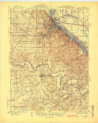
1945 Map of Hannibal
USGS Topo · Published 1945About this map
Hannibal serves as the dominant river hub on this 1945 sheet, where the Mississippi River meets a complex network of rail lines including the Chicago Burlington and Quincy and the Wabash. The landscape is characterized by a high density of rural schoolhouses and family-named landmarks, such as Withers Mill and Providence Sch, reflecting the established community structure of Marion and Ralls counties. Key institutions like Hannibal La Grange College and the Court House stand at the center of civic life, while the Mark Twain Landing Field represents mid-century transportation infrastructure.
Find a feature on this map
87 named features on this map. Tap any name to fly to it.
Don’t see what you’re looking for? This feature index may not catch every label — zoom into the map to look around manually.
Map Details
Editions of this 1945 Hannibal Map
2 editions found
Other maps of this area

1890 · Louisiana
USGS Topo · 1:125,000

1890 · Mexico
USGS Topo · 1:125,000

1903 · Palmyra
USGS Topo · 1:125,000

1925 · Quincy
USGS Topo · 1:62,500

1925 · Liberty
USGS Topo · 1:62,500

1927 · Liberty
USGS Topo · 1:62,500

1931 · Barry
USGS Topo · 1:62,500

1932 · Hannibal
USGS Topo · 1:62,500

1936 · Hannibal
USGS Topo · 1:48,000

1936 · Barry
USGS Topo · 1:48,000