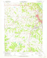
1971 Map of Hannibal West
USGS Topo · Published 1973About this map
Hannibal and its western outskirts are depicted here during a period of significant regional expansion, where the traditional river and rail corridors met new suburban developments. Educational and religious institutions anchor the community, notably St Thomas Seminary and Missouri Baptist College, while local industry is represented by numerous mines and a quarry near Ralls. The landscape is a complex network of water and transit, from the Ziegler Island chutes to the tracks of the Burlington Northern and Norfolk and Western railroads. Smaller rural nodes like Withers Mill and Hydesburg persist alongside newer landmarks such as the Huck Finn Shopping Center and a Drive-in Theater. Genealogists will find a high density of family and community burial sites, including Barkley Cem, Bush Cem, and the Minor-Sandidge Cem.
Find a feature on this map
70 named features on this map. Tap any name to fly to it.
Don’t see what you’re looking for? This feature index may not catch every label — zoom into the map to look around manually.
Map Details
Editions of this 1971 Hannibal West Map
2 editions found
Other maps of this area

1903 · Palmyra
USGS Topo · 1:125,000

1925 · Quincy
USGS Topo · 1:62,500

1932 · Hannibal
USGS Topo · 1:62,500

1936 · Hannibal
USGS Topo · 1:48,000

1944 · Quincy
USGS Topo · 1:62,500

1945 · Hannibal
USGS Topo · 1:62,500

1945 · Quincy
USGS Topo · 1:62,500

1948 · Quincy
USGS Topo · 1:250,000

1949 · Palmyra
USGS Topo · 1:24,000

1950 · Palmyra
USGS Topo · 1:24,000