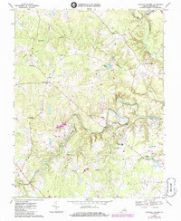
1969 Map of Hanover Academy
USGS Topo · Published 1985About this map
Scotchtown and the surrounding Hanover County countryside are defined by a complex network of waterways and historic crossroads. The South Anna River winds through the center of the sheet, joined by smaller tributaries like Needham Creek and Cedar Creek. Evidence of the region’s long-standing educational and social foundations is clear in the presence of Hanover Academy and numerous rural houses of worship, including Fork Ch and Ebenezer Ch. Local transportation in the late 1960s relied on several distinctive crossings such as Ground Squirrel Bridge and Blunts Bridge. The map captures the western edge of Ashland and the settlement of Negro Foot, showing a landscape of small communities, scattered cemeteries, and light industry like the Quarry near the Little River. Purple revisions from the mid-1980s highlight changes like the Janeway Airstrip, indicating the gradual modernization of this Piedmont landscape.
Find a feature on this map
43 named features on this map. Tap any name to fly to it.
Don’t see what you’re looking for? This feature index may not catch every label — zoom into the map to look around manually.
Map Details
Editions of this 1969 Hanover Academy Map
4 editions found
Other maps of this area

1890 · Goochland
USGS Topo · 1:125,000

1892 · Goochland
USGS Topo · 1:125,000

1894 · Richmond
USGS Topo · 1:62,500

1895 · Richmond
USGS Topo · 1:62,500

1918 · Doswell
USGS Topo · 1:62,500

1936 · Glen Allen
USGS Topo · 1:24,000

1938 · Yellow Tavern
USGS Topo · 1:31,680

1941 · Glen Allen
USGS Topo · 1:31,680

1942 · Beaverdam
USGS Topo · 1:24,000

1943 · Mabelton
USGS Topo · 1:31,680