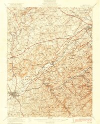
1922 Map of Hanover
USGS Topo · Published 1922About this map
Hanover and its surrounding rural townships are defined by a complex network of early 20th-century transportation, where the Pennsylvania RR and Western Maryland RR intersect near Pennville. This agricultural and industrial landscape is dotted with a high density of one-room schoolhouses, including the John Mummert School and Moses Mummert School, reflecting the local importance of family-named landmarks. The terrain rises into the Pigeon Hills, creating a natural barrier between the drainages of Conewago Creek and Codorus Creek. Many small crossroads communities like Gnadstown and Admire appear before later suburban expansion, while industrial sites like Kraft Mill and various gravel pits suggest the early economy. The inclusion of the Lincoln Highway crossing through Thomasville marks a pivotal moment in the transition from rail-dependent commerce to the modern automotive era.
Find a feature on this map
159 named features on this map. Tap any name to fly to it.
Don’t see what you’re looking for? This feature index may not catch every label — zoom into the map to look around manually.
Map Details
Editions of this 1922 Hanover Map
5 editions found

Other maps of this area

1900 · Parkton
USGS Topo · 1:62,500

1902 · Parkton
USGS Topo · 1:62,500

1904 · Carlisle
USGS Topo · 1:62,500

1905 · Westminster
USGS Topo · 1:62,500

1906 · New Cumberland
USGS Topo · 1:62,500

1908 · Middletown
USGS Topo · 1:62,500

1908 · Gettysburg
USGS Topo · 1:62,500

1908 · York
USGS Topo · 1:62,500

1910 · York
USGS Topo · 1:62,500

1911 · Taneytown
USGS Topo · 1:62,500