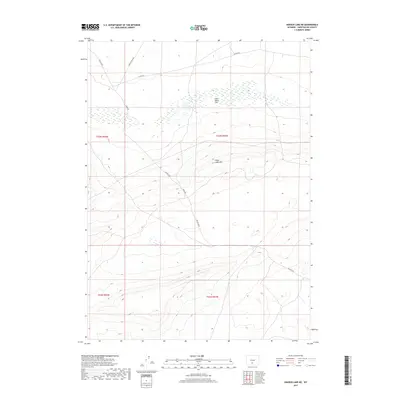
2017 Map of Hansen Lake NE
USGS Topo · Published 2017About this map
Chain Lakes Flat and the surrounding high desert terrain define this corner of Sweetwater County, Wyoming. The landscape is characterized by its dramatic elevation changes, most notably along the Chain Lakes Rim, which separates the lower alkaline flats from the higher mesas. This modern survey illustrates the specialized road network used to navigate the Red Desert, where remote access is provided by routes such as Riner Rd and Riner Cutoff Rd. These tracks connect scattered Bureau of Land Management routes, including BLM Rd 3203 and BLM Rd 3303, which trace the contours of the arid basins and township boundaries. The map provides a clear look at the Public Land Survey System grid, including corners for t23n r92w and t23n r93w, essential for locating land parcels and historic grazing rights in this open range.
Find a feature on this map
11 named features on this map. Tap any name to fly to it.
Don’t see what you’re looking for? This feature index may not catch every label — zoom into the map to look around manually.
Map Details
Editions of this 2017 Hansen Lake NE Map
This is the sole edition of this map. No revisions or reprints were ever made.
Other maps of this area

1954 · Rawlins
USGS Topo · 1:250,000

1955 · Casper
USGS Topo · 1:250,000

1958 · Rawlins
USGS Topo · 1:250,000

1958 · Casper
USGS Topo · 1:250,000

1960 · Battle Spring
USGS Topo · 1:24,000

1960 · Hansen Lake NE
USGS Topo · 1:24,000

1960 · Sooner Reservoir
USGS Topo · 1:24,000

1960 · Larsen Knoll
USGS Topo · 1:24,000

1960 · Hansen Lake
USGS Topo · 1:24,000

1960 · Chicken Spring
USGS Topo · 1:24,000