
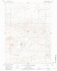
1960 Map of Larsen Knoll
USGS Topo · Published 1962About this map
Larsen Ranch serves as a lone human waypoint in this high-desert landscape of Sweetwater County, documented during the early 1960s. The terrain is defined by a series of distinct elevations, notably Larsen Knoll, Stratton Knoll, and Johnson Knoll, which overlook a complex hydrology of seasonal and permanent basins. Significant water features like Mud Springs Lake and the Chain Lakes system are surrounded by expansive alkali or mud surfaces, including Mud Springs Flats and Chain Lakes Flat. A segment of the Riner Cutoff Road and a nearby Pipeline indicate the persistent utility of this corridor for regional transit and resource management. This survey provides a precise record of the land before significant modern development, capturing the essential cattle ranching and watering infrastructure of the era through various Corrals and a remote Well.
Find a feature on this map
13 named features on this map. Tap any name to fly to it.
Don’t see what you’re looking for? This feature index may not catch every label — zoom into the map to look around manually.
Map Details
Editions of this 1960 Larsen Knoll Map
2 editions found
Other maps of this area

1954 · Rawlins
USGS Topo · 1:250,000

1955 · Casper
USGS Topo · 1:250,000

1958 · Rawlins
USGS Topo · 1:250,000

1958 · Casper
USGS Topo · 1:250,000

1960 · Hansen Lake NE
USGS Topo · 1:24,000

1960 · Sooner Reservoir
USGS Topo · 1:24,000

1960 · Bull Springs
USGS Topo · 1:24,000

1960 · Buck Draw
USGS Topo · 1:24,000

1960 · Chicken Spring
USGS Topo · 1:24,000

1962 · Rawlins
USGS Topo · 1:250,000