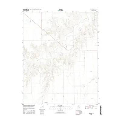
2016 Map of Hansford
USGS Topo · Published 2016About this map
Hansford Cem serves as a silent landmark on the high plains of the Texas Panhandle, marking a central point of historical interest in this Hansford County landscape. The terrain is defined by the winding course of Horse Cr, which carves deep, complex drainage patterns through the surrounding tableland. While much of the area is organized by a geometric grid of county roads such as Co RD 16 and Co RD 18, the settlement of McKibben sits at the southwestern edge of the survey, reflecting the sparse, cattle-and-crop-driven distribution of the region. The map captures a moment in the mid-2010s where the intersection of state-maintained routes like Fm 2018 and Fm 2387 connects remote homesteads and agricultural operations across the rugged breaks of the Canadian River watershed.
Find a feature on this map
15 named features on this map. Tap any name to fly to it.
Don’t see what you’re looking for? This feature index may not catch every label — zoom into the map to look around manually.
Map Details
Editions of this 2016 Hansford Map
This is the sole edition of this map. No revisions or reprints were ever made.
Other maps of this area

1954 · Perryton
USGS Topo · 1:250,000

1958 · Perryton
USGS Topo · 1:250,000

1962 · Kimball
USGS Topo · 1:24,000

1962 · Hansford
USGS Topo · 1:24,000

1962 · Waka SW
USGS Topo · 1:24,000

1962 · Spearman
USGS Topo · 1:24,000

1973 · Gruver
USGS Topo · 1:24,000

1974 · Morse
USGS Topo · 1:24,000

1974 · Hannas Draw East
USGS Topo · 1:24,000
1974 · Holt
USGS Topo · 1:24,000