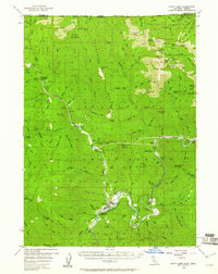
1956 Map of Happy Camp
USGS Topo · Published 1961About this map
The Klamath River flows through the center of this mountainous region, anchoring the settlement of Happy Camp during the mid-1950s. This survey reveals an economy deeply rooted in resource extraction and forest management, illustrated by the density of lode and placer operations such as the Gray Eagle Mine, Richardson Bedrock Mine, and China Cr Placer Mine. A network of creeks, including Indian Creek and Thompson Creek, feeds into the Klamath, while high-altitude points like Slater Butte Lookout and China Peak Lookout provide strategic oversight of the Klamath National Forest. Evidence of former habitation appears at the Nolton (Site) on the northern bank of the river. The landscape is also marked by essential infrastructure for the era, ranging from the Happy Camp Airport and Millpond Substation to remote shelters like Baileys Cabin.
Find a feature on this map
139 named features on this map. Tap any name to fly to it.
Don’t see what you’re looking for? This feature index may not catch every label — zoom into the map to look around manually.
Map Details
Editions of this 1956 Happy Camp Map
3 editions found

Other maps of this area

1908 · Grants Pass
USGS Topo · 1:125,000

1914 · Seiad
USGS Topo · 1:125,000

1917 · Kerby
USGS Topo · 1:125,000

1918 · Kerby
USGS Topo · 1:125,000

1922 · Preston Peak
USGS Topo · 1:125,000

1922 · Seiad
USGS Topo · 1:125,000

1945 · Kerby
USGS Topo · 1:125,000

1948 · Weed
USGS Topo · 1:250,000

1950 · Weed
USGS Topo · 1:250,000

1954 · Cave Junction
USGS Topo · 1:62,500