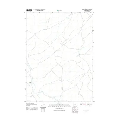
2012 Map of Happy Spring
USGS Topo · Published 2012About this map
The Emigrant Trl cuts a historic path through this high desert region of Fremont County, marking the long-established transit corridors of the American West. The landscape is defined by its seasonal hydrology, where drainage systems like Warm Springs Cr and Alkali Cr carve through the arid terrain. The presence of the Happy Spring Sheep Camp near the center of the map indicates the continued importance of the open range and livestock industry in Wyoming's high country. To the southwest, Coyote Gulch and Coyote Lake provide distinct geographic markers in a territory largely accessed via primitive routes like Bison Basin Rd. This survey documents a quiet interior landscape where water sources like Happy Spring and Warm Springs have served as vital waypoints for generations of travelers and ranchers alike.
Find a feature on this map
12 named features on this map. Tap any name to fly to it.
Don’t see what you’re looking for? This feature index may not catch every label — zoom into the map to look around manually.
Map Details
Editions of this 2012 Happy Spring Map
This is the sole edition of this map. No revisions or reprints were ever made.
Other maps of this area

1951 · Soap Holes
USGS Topo · 1:24,000

1951 · Myers Ranch
USGS Topo · 1:24,000

1953 · Barras Springs
USGS Topo · 1:24,000

1953 · Sweetwater Station
USGS Topo · 1:24,000

1953 · Happy Spring
USGS Topo · 1:24,000

1953 · Red Canyon
USGS Topo · 1:24,000

1955 · Lander
USGS Topo · 1:250,000
1957 · Red Canyon
USGS Topo · 1:24,000

1958 · Lander
USGS Topo · 1:250,000

1961 · Lander
USGS Topo · 1:250,000