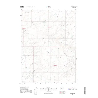
2017 Map of Happy Spring
USGS Topo · Published 2017About this map
The Emigrant Trl cuts across the high desert landscape of Fremont County, marking a corridor of historical travel through the northern portion of this quadrangle. This 2017 survey illustrates a land defined by its scarce but vital water sources, including the eponymous Happy Spring and the nearby Warm Springs. The drainage patterns of Alkali Cr and its eastern and western branches dominate the southwestern terrain, leading toward Coyote Lake. Significant relief is found at Bull Canyon and Coyote Gulch, which provide verticality to an otherwise steady incline. Modern recreational and conservation efforts are represented by the Continental Divide National Scenic Trail-Wyoming Portion, which winds through the southeastern corner, while Bison Basin Rd provides the primary north-south vehicular access through this section of the Great Divide Basin.
Find a feature on this map
17 named features on this map. Tap any name to fly to it.
Don’t see what you’re looking for? This feature index may not catch every label — zoom into the map to look around manually.
Map Details
Editions of this 2017 Happy Spring Map
This is the sole edition of this map. No revisions or reprints were ever made.
Other maps of this area

1951 · Soap Holes
USGS Topo · 1:24,000

1951 · Myers Ranch
USGS Topo · 1:24,000

1953 · Barras Springs
USGS Topo · 1:24,000

1953 · Sweetwater Station
USGS Topo · 1:24,000

1953 · Happy Spring
USGS Topo · 1:24,000

1953 · Red Canyon
USGS Topo · 1:24,000

1955 · Lander
USGS Topo · 1:250,000
1957 · Red Canyon
USGS Topo · 1:24,000

1958 · Lander
USGS Topo · 1:250,000

1961 · Lander
USGS Topo · 1:250,000