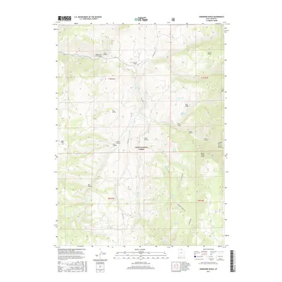
2017 Map of Hardware Ranch
USGS Topo · Published 2017About this map
Hardware Ranch serves as a central landmark in this portion of the Cache National Forest, where the high-altitude landscape is defined by the complex drainage of the Blacksmith Fork river. This 2017 survey details a network of canyons and ridges, including Blacksmith Fork Canyon and the prominent Monte Cristo Range to the southeast. The map reveals how the terrain dictates movement through the region, with Laketown Rd and Ant Flat Rd following natural corridors between peaks like Gold Hill and Deer Ridge. Numerous water sources, such as Tilda Springs and Whiskey Spring, are meticulously plotted across the drainage basins of Sheep Cr and Mill Cr, highlighting the vital locations that supported ranching and forest management in this part of northern Utah.
Find a feature on this map
44 named features on this map. Tap any name to fly to it.
Don’t see what you’re looking for? This feature index may not catch every label — zoom into the map to look around manually.
Map Details
Editions of this 2017 Hardware Ranch Map
This is the sole edition of this map. No revisions or reprints were ever made.
Other maps of this area

1912 · Randolph
USGS Topo · 1:125,000

1914 · Logan
USGS Topo · 1:125,000

1916 · Logan
USGS Topo · 1:125,000

1949 · Boulter Mts
USGS Topo · 1:24,000

1954 · Ogden
USGS Topo · 1:250,000

1958 · Ogden
USGS Topo · 1:250,000

1960 · Ogden
USGS Topo · 1:250,000

1964 · Monte Cristo PK
USGS Topo · 1:24,000
1964 · Sharp Mountain
USGS Topo · 1:24,000

1968 · Dairy Ridge
USGS Topo · 1:24,000