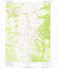
1969 Map of Hardware Ranch
USGS Topo · Published 1973About this map
Hardware Ranch serves as a focal point in this high-country landscape within the Cache National Forest. In the late 1960s, the area was characterized by a network of ranching outposts and rugged resource management, evidenced by the presence of a Gravel Pit, a Gaging Station, and remote sites like Anderson Ranch. The topography is defined by the deep incision of Blacksmith Fork and its namesake canyon, where the drainage meets Curtis Creek near Camp Wapiti. Numerous springs, such as East Mud Spring and Whiskey Spring, dot the ridges, highlighting the vital water sources for local livestock. The map also reveals traces of early inhabitants and travelers through a solitary Grave near the main ranch and several established trails, including Petes Trail, which traverse the high ground of Ant Valley and Curtis Ridge.
Find a feature on this map
74 named features on this map. Tap any name to fly to it.
Don’t see what you’re looking for? This feature index may not catch every label — zoom into the map to look around manually.
Map Details
Editions of this 1969 Hardware Ranch Map
This is the sole edition of this map. No revisions or reprints were ever made.
Other maps of this area

1912 · Randolph
USGS Topo · 1:125,000

1914 · Logan
USGS Topo · 1:125,000

1916 · Logan
USGS Topo · 1:125,000

1949 · Boulter Mts
USGS Topo · 1:24,000

1954 · Ogden
USGS Topo · 1:250,000

1958 · Ogden
USGS Topo · 1:250,000

1960 · Ogden
USGS Topo · 1:250,000

1964 · Monte Cristo PK
USGS Topo · 1:24,000
1964 · Sharp Mountain
USGS Topo · 1:24,000

1968 · Dairy Ridge
USGS Topo · 1:24,000