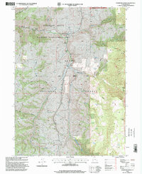
1998 Map of Hardware Ranch
USGS Topo · Published 2001About this map
Hardware Ranch serves as a focal point for this mountain landscape in the late 1990s, situated at the confluence of several high-country drainages. The area is dominated by the Hardware Ranch Wildlife Management Area and the Cache National Forest, showing a network of trails and 4WD roads that navigate the complex topography of Ant Valley and Curtis Ridge. A solitary Grave near the main ranch buildings and the Anderson Ranch to the south offer specific points of interest for genealogists tracing early settlement in Cache County.
Find a feature on this map
46 named features on this map. Tap any name to fly to it.
Don’t see what you’re looking for? This feature index may not catch every label — zoom into the map to look around manually.
Map Details
Editions of this 1998 Hardware Ranch Map
This is the sole edition of this map. No revisions or reprints were ever made.
Other maps of this area

1912 · Randolph
USGS Topo · 1:125,000

1914 · Logan
USGS Topo · 1:125,000

1916 · Logan
USGS Topo · 1:125,000

1949 · Boulter Mts
USGS Topo · 1:24,000

1954 · Ogden
USGS Topo · 1:250,000

1958 · Ogden
USGS Topo · 1:250,000

1960 · Ogden
USGS Topo · 1:250,000

1964 · Monte Cristo PK
USGS Topo · 1:24,000
1964 · Sharp Mountain
USGS Topo · 1:24,000

1968 · Dairy Ridge
USGS Topo · 1:24,000