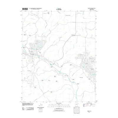
2011 Map of Hardy
USGS Topo · Published 2011About this map
Hardy and Ozark Acres anchor this corner of the Ozark foothills, where residential development and recreation meet the natural course of the Spring River. The 2011 landscape is defined by its water management, featuring several significant engineered barriers including the Rainbow Lake Dam, Lake Sherwood Dam, and Spring Lake Dam. These impoundments created leisure-focused communities like Vagabond Lake and Lake Sherwood, contrasting with the more traditional rural outposts of Sellers Store and Baker.
Find a feature on this map
119 named features on this map. Tap any name to fly to it.
Don’t see what you’re looking for? This feature index may not catch every label — zoom into the map to look around manually.
Map Details
Editions of this 2011 Hardy Map
This is the sole edition of this map. No revisions or reprints were ever made.
Other maps of this area

1957 · Poplar Bluff
USGS Topo · 1:250,000

1959 · Poplar Bluff
USGS Topo · 1:250,000

1960 · Poplar Bluff
USGS Topo · 1:250,000

1962 · Stuart
USGS Topo · 1:24,000

1962 · Ash Flat
USGS Topo · 1:24,000

1962 · Mammoth Spring
USGS Topo · 1:24,000

1968 · Hardy
USGS Topo · 1:24,000
1968 · Hardy NE
USGS Topo · 1:24,000
1968 · Wirth
USGS Topo · 1:24,000
1968 · Ravenden
USGS Topo · 1:24,000