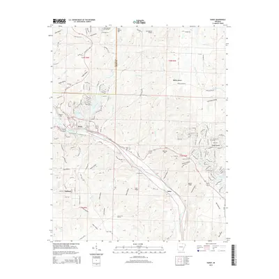
2014 Map of Hardy
USGS Topo · Published 2014About this map
The Spring River winds through this Ozark landscape, serving as a central geographic anchor for the communities of Hardy and Highland. This 2014 survey captures a region defined by its narrow valleys and prominent ridges, such as Goat Ridge and Walker Ridge, where the boundary between Fulton and Sharp counties divides the upland terrain. The map reveals a high density of small-scale water features and recreational lakes, including Rainbow Lake, Lake Sherwood, and Vagabond Lake, which reflect the area's development as a residential and vacation destination.
Find a feature on this map
158 named features on this map. Tap any name to fly to it.
Don’t see what you’re looking for? This feature index may not catch every label — zoom into the map to look around manually.
Map Details
Editions of this 2014 Hardy Map
This is the sole edition of this map. No revisions or reprints were ever made.
Other maps of this area

1957 · Poplar Bluff
USGS Topo · 1:250,000

1959 · Poplar Bluff
USGS Topo · 1:250,000

1960 · Poplar Bluff
USGS Topo · 1:250,000

1962 · Stuart
USGS Topo · 1:24,000

1962 · Ash Flat
USGS Topo · 1:24,000

1962 · Mammoth Spring
USGS Topo · 1:24,000

1968 · Hardy
USGS Topo · 1:24,000
1968 · Hardy NE
USGS Topo · 1:24,000
1968 · Wirth
USGS Topo · 1:24,000
1968 · Ravenden
USGS Topo · 1:24,000