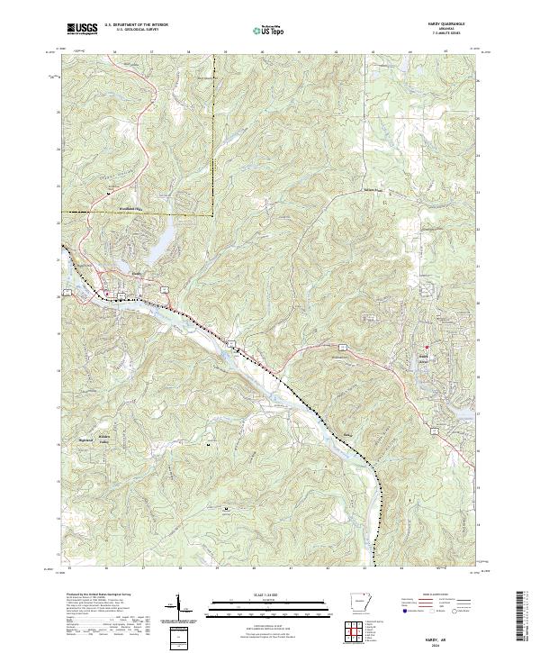
2024 Map of Hardy
USGS Topo · Published 2024About this map
The Spring River winds through the heart of the Ozarks in this recent mapping of the Sharp County and Fulton County border. The community of Hardy serves as a central hub, situated near the river and Rainbow Lake. The landscape is characterized by a dense network of hollows and ridges, including Stapps Hollow, Fuller Hollow, and Walker Ridge, which illustrate the complex topography that has long shaped local travel and settlement.
Find a feature on this map
148 named features on this map. Tap any name to fly to it.
Don’t see what you’re looking for? This feature index may not catch every label — zoom into the map to look around manually.
Map Details
Editions of this 2024 Hardy Map
This is the sole edition of this map. No revisions or reprints were ever made.
Other maps of this area

1957 · Poplar Bluff
USGS Topo · 1:250,000

1959 · Poplar Bluff
USGS Topo · 1:250,000

1960 · Poplar Bluff
USGS Topo · 1:250,000

1962 · Stuart
USGS Topo · 1:24,000

1962 · Ash Flat
USGS Topo · 1:24,000

1962 · Mammoth Spring
USGS Topo · 1:24,000

1968 · Hardy
USGS Topo · 1:24,000
1968 · Hardy NE
USGS Topo · 1:24,000
1968 · Wirth
USGS Topo · 1:24,000
1968 · Ravenden
USGS Topo · 1:24,000