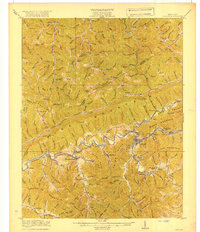
1919 Map of Harlan
USGS Topo · Published 1919About this map
Harlan serves as the focal point of this 1916 survey, situated at the confluence where the Cumberland River meets its Clover Fork and Martins Fork. The era's industrial footprint is clearly marked by the Louisville and Nashville railroad, which snakes through the narrow valleys to serve coal-adjacent settlements like Coxton, Kitts, and White Star. This map documents the complex topography of the Cumberland Plateau before modern development, showing the intricate system of ridges like Pine Mountain and Little Black Mountain that dictated the region's settlement patterns.
Find a feature on this map
112 named features on this map. Tap any name to fly to it.
Don’t see what you’re looking for? This feature index may not catch every label — zoom into the map to look around manually.
Map Details
Editions of this 1919 Harlan Map
4 editions found

Other maps of this area

1886 · Cumberland Gap
USGS Topo · 1:125,000

1887 · Jonesville
USGS Topo · 1:125,000

1888 · Cumberland Gap
USGS Topo · 1:125,000

1891 · Manchester
USGS Topo · 1:125,000

1891 · Cumberland Gap
USGS Topo · 1:125,000

1891 · Hazard
USGS Topo · 1:125,000

1891 · Jonesville
USGS Topo · 1:125,000

1903 · Harlan
USGS Topo · 1:48,000

1903 · Pineville
USGS Topo · 1:48,000

1903 · Middlesboro
USGS Topo · 1:48,000