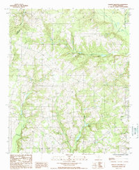
1988 Map of Harleys Millpond
USGS Topo · Published 1988About this map
Livingston serves as a primary settlement point in this region of South Carolina, situated where the landscape transitions through a network of creeks and wetlands feeding into the North Fork Edisto River. The water-driven economy and land use of the late 20th century are evident in features like Harleys Millpond and Prester Millpond, while several unnamed Cem sites suggest local family burial grounds throughout the countryside. A prominent Aiken Co Orangeburg Co boundary line divides the territory, which is further defined by modern infrastructure such as a Landing Strip, a Radio Tower, and a Lookout Tower. The drainage patterns of Bolen Mill Creek, Rocky Swamp Creek, and Little Beaver Creek illustrate the low-lying, swampy nature of the terrain, punctuated by clearings for agriculture and utility corridors including a Pipeline and Trans Line.
Find a feature on this map
23 named features on this map. Tap any name to fly to it.
Don’t see what you’re looking for? This feature index may not catch every label — zoom into the map to look around manually.
Map Details
Editions of this 1988 Harleys Millpond Map
This is the sole edition of this map. No revisions or reprints were ever made.
Other maps of this area

1919 · Bamberg
USGS Topo · 1:48,000

1920 · Bamberg
USGS Topo · 1:62,500

1923 · Williston
USGS Topo · 1:48,000

1927 · Williston
USGS Topo · 1:62,500

1943 · Bamberg
USGS Topo · 1:62,500

1943 · Williston
USGS Topo · 1:62,500

1944 · Seivern
USGS Topo · 1:62,500

1946 · Woodford
USGS Topo · 1:62,500

1954 · Augusta
USGS Topo · 1:250,000

1957 · Augusta
USGS Topo · 1:250,000