
1920 Map of Harmaston
USGS Topo · Published 1920About this map
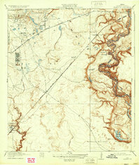
The San Jacinto River meanders through the eastern edge of this Harris County terrain, its oxbows creating a complex system of water bodies like Bird Lake, Sand Lake, and Mud Lake. This 1916 survey captures the area during a period of transition as industrial infrastructure began to punctuate the coastal prairie and woodlands. A significant concentration of Oil Tanks is visible near Garners Bayou, indicating the early 20th-century petroleum boom's local footprint.
Find a feature on this map
23 named features on this map. Tap any name to fly to it.
Don’t see what you’re looking for? This feature index may not catch every label — zoom into the map to look around manually.
Map Details
Editions of this 1920 Harmaston Map
2 editions found
Other maps of this area

1916 · Burnett Bay
USGS Topo · 1:24,000

1916 · Crosby
USGS Topo · 1:24,000

1916 · Settegast
USGS Topo · 1:24,000

1916 · Fauna
USGS Topo · 1:24,000

1916 · Harmaston
USGS Topo · 1:24,000

1916 · Moonshine Hill
USGS Topo · 1:24,000

1916 · Huffman
USGS Topo · 1:24,000

1916 · Humble
USGS Topo · 1:24,000

1919 · Humble
USGS Topo · 1:31,680

1919 · Weeden
USGS Topo · 1:31,680