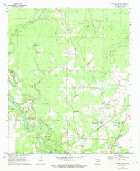
1971 Map of Harmony Grove
USGS Topo · Published 1973About this map
The Ouachita River meanders through the western reaches of this Ouachita County landscape, where an intricate network of sloughs and oxbow lakes like Big Dizon Lake and Fishers Lake define the bottomlands. The settlement of Harmony Grove serves as a central hub, surrounded by family and community landmarks such as Harmony Grove Cem and Bethel Temple. Transportation patterns are clearly visible through the St Louis Southwestern RR corridor and a prominent Old Railroad Grade that speaks to earlier industrial routes through the timber-rich terrain.
Find a feature on this map
40 named features on this map. Tap any name to fly to it.
Don’t see what you’re looking for? This feature index may not catch every label — zoom into the map to look around manually.
Map Details
Editions of this 1971 Harmony Grove Map
2 editions found
Other maps of this area

1903 · Camden
USGS Topo · 1:125,000

1951 · Camden
USGS Topo · 1:24,000

1953 · El Dorado
USGS Topo · 1:250,000

1957 · El Dorado
USGS Topo · 1:250,000

1958 · El Dorado
USGS Topo · 1:250,000

1960 · El Dorado
USGS Topo · 1:250,000

1971 · Tates Bluff
USGS Topo · 1:24,000

1971 · Ouachita
USGS Topo · 1:24,000
1971 · Camden
USGS Topo · 1:24,000
1971 · Bragg City
USGS Topo · 1:24,000