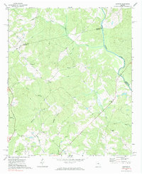
1972 Map of Harmony
USGS Topo · Published 1984About this map
Oconee National Forest covers much of this landscape in eastern Putnam Co, where the land descends toward the winding Oconee River. Small rural settlements like Harmony and Jefferson are connected by a network of creeks and branches, including Clarks Fork, Jacks Fork, and Lick Creek. The terrain is deeply inscribed with family and community history, evidenced by several country churches such as Lone Oak Ch, Ward Chapel, and Henderson Grove Ch. A large Pipeline cuts across the southern portion of the map, contrasting with the more traditional land use patterns of the area. This 1972 survey, photoinspected in the early 1980s, captures a snapshot of middle Georgia's forested interior before significant modern development, showing isolated homesites and remote cemeteries reached only by Jeep Trails.
Find a feature on this map
30 named features on this map. Tap any name to fly to it.
Don’t see what you’re looking for? This feature index may not catch every label — zoom into the map to look around manually.
Map Details
Editions of this 1972 Harmony Map
Other maps of this area

1953 · Athens
USGS Topo · 1:250,000

1958 · Athens
USGS Topo · 1:250,000

1959 · Athens
USGS Topo · 1:250,000

1963 · Athens
USGS Topo · 1:250,000

1972 · Liberty
USGS Topo · 1:24,000

1972 · Meda
USGS Topo · 1:24,000

1972 · Eatonton
USGS Topo · 1:24,000

1972 · Buckhead
USGS Topo · 1:24,000

1972 · Harmony
USGS Topo · 1:24,000

1972 · Rock Eagle Lake
USGS Topo · 1:24,000