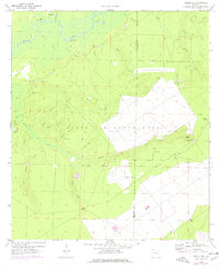
1970 Map of Harold SE
USGS Topo · Published 1977About this map
Eglin Air Force Base dominates the southern landscape of this Santa Rosa County quadrangle, showing the operational infrastructure of Aux Field No 7 and several monitoring towers. This military presence contrasts with the riparian terrain of the Yellow River corridor to the north, where traditional river-access points like Flowers Field Landing and the small settlement of Parkerville hint at a different era of local commerce. Between the river and the base, a network of namesake branches and hollows—including Fishtrap Branch, Roaring Branch, and Big Hollow—drain the pine-heavy sands. Local history is anchored by sites like Flowers Field Cem and Miller Bluff, while early industrial activity is evidenced by a Claypit near the base boundary. The 1976 revisions, marked in purple, highlight evolving facilities such as the Radio Tower and expanded structures within the base perimeter.
Find a feature on this map
37 named features on this map. Tap any name to fly to it.
Don’t see what you’re looking for? This feature index may not catch every label — zoom into the map to look around manually.
Map Details
Editions of this 1970 Harold SE Map
2 editions found
Other maps of this area

1921 · Holley
USGS Topo · 1:62,500

1934 · Holt
USGS Topo · 1:48,000

1934 · Harold
USGS Topo · 1:62,500

1936 · Holley
USGS Topo · 1:48,000

1937 · Holt
USGS Topo · 1:62,500

1937 · Harold
USGS Topo · 1:62,500

1938 · Mary Esther
USGS Topo · 1:62,500

1938 · Holley
USGS Topo · 1:62,500

1938 · Harold
USGS Topo · 1:62,500

1956 · Fort Walton Beach
USGS Topo · 1:62,500