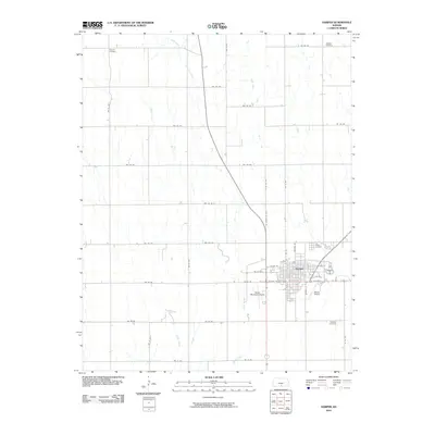
2010 Map of Harper
USGS Topo · Published 2010About this map
Harper serves as the primary hub of activity on this southern Kansas landscape, where the grid of city streets like Central St and Ash St meets the wide-open prairie. The map reveals a community supported by a mix of aviation and agriculture, featuring both the Harper Municipal Airport and the smaller Dewey Airport. Outside the town center, the terrain is defined by a strictly surveyed section-line road system, including routes like NW 140 Rd and NW 40 Ave, which cross the drainage basins of Spring Creek, Sand Creek, and Rush Creek. For genealogists and local historians, the sheet is particularly valuable for its placement of scattered burial grounds including Duquoin Cemetery in the northwest, Hillsdale Cemetery in the northeast, and the Christian Cemetery to the southeast, documenting the historical footprint of the county's rural residents.
Find a feature on this map
39 named features on this map. Tap any name to fly to it.
Don’t see what you’re looking for? This feature index may not catch every label — zoom into the map to look around manually.
Map Details
Editions of this 2010 Harper Map
This is the sole edition of this map. No revisions or reprints were ever made.
Other maps of this area

1889 · Anthony
USGS Topo · 1:125,000

1889 · Caldwell
USGS Topo · 1:125,000

1891 · Anthony
USGS Topo · 1:125,000

1893 · Caldwell
USGS Topo · 1:125,000

1897 · Caldwell
USGS Topo · 1:125,000

1955 · Wichita
USGS Topo · 1:250,000

1955 · Pratt
USGS Topo · 1:250,000

1958 · Wichita
USGS Topo · 1:250,000

1959 · Pratt
USGS Topo · 1:250,000
1971 · Adams
USGS Topo · 1:24,000