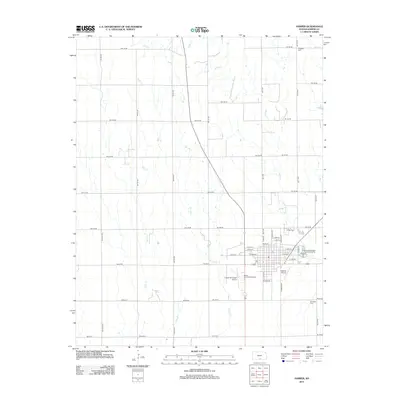
2012 Map of Harper
USGS Topo · Published 2012About this map
Harper serves as the primary hub of activity in this section of south-central Kansas, where the grid of the city meets the broad agricultural section lines. The landscape is defined by the drainage patterns of Spring Cr, Rush Cr, and Sand Cr, which cut through the township's uniform road network. Aviation and community infrastructure are prominent, with both the Harper Municipal Airport and the smaller Deweze Airport situated near the city's southern edge alongside the Harper County Fairgrounds. Local heritage is anchored by three distinct burial grounds—Harper Cem, Hillsdale Cem, and Christian Cem—which provide essential touchpoints for genealogical research. The street layout of the town center, including W Main St and N Ash St, reflects a settled rural economy built around the intersection of regional state routes.
Find a feature on this map
53 named features on this map. Tap any name to fly to it.
Don’t see what you’re looking for? This feature index may not catch every label — zoom into the map to look around manually.
Map Details
Editions of this 2012 Harper Map
This is the sole edition of this map. No revisions or reprints were ever made.
Other maps of this area

1889 · Anthony
USGS Topo · 1:125,000

1889 · Caldwell
USGS Topo · 1:125,000

1891 · Anthony
USGS Topo · 1:125,000

1893 · Caldwell
USGS Topo · 1:125,000

1897 · Caldwell
USGS Topo · 1:125,000

1955 · Wichita
USGS Topo · 1:250,000

1955 · Pratt
USGS Topo · 1:250,000

1958 · Wichita
USGS Topo · 1:250,000

1959 · Pratt
USGS Topo · 1:250,000
1971 · Adams
USGS Topo · 1:24,000