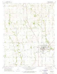
1973 Map of Harper
USGS Topo · Published 1975About this map
The town of Harper serves as the central hub of this mid-1970s survey, showing a well-established grid of streets and local infrastructure at the junction of major transportation corridors. The Atchison Topeka And Santa Fe railroad cuts diagonally across the prairie landscape, mirroring the path of the regional highway system. Outside of the residential center, the land is marked by agricultural use and small-scale extractive industries, evidenced by numerous Oil Wells, Drill Holes, and several Sandpit operations along the creek beds.
Find a feature on this map
20 named features on this map. Tap any name to fly to it.
Don’t see what you’re looking for? This feature index may not catch every label — zoom into the map to look around manually.
Map Details
Editions of this 1973 Harper Map
This is the sole edition of this map. No revisions or reprints were ever made.
Other maps of this area

1889 · Anthony
USGS Topo · 1:125,000

1889 · Caldwell
USGS Topo · 1:125,000

1891 · Anthony
USGS Topo · 1:125,000

1893 · Caldwell
USGS Topo · 1:125,000

1897 · Caldwell
USGS Topo · 1:125,000

1955 · Wichita
USGS Topo · 1:250,000

1955 · Pratt
USGS Topo · 1:250,000

1958 · Wichita
USGS Topo · 1:250,000

1959 · Pratt
USGS Topo · 1:250,000
1971 · Adams
USGS Topo · 1:24,000