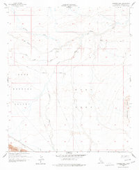
1956 Map of Harpers Well
USGS Topo · Published 1977About this map
Harpers Well and the surrounding desert landscape of Imperial County are defined by a network of ephemeral watercourses and early travel routes. This mid-century topography reveals a sparsely settled region where the Old Kane Spring Road and various Jeep Trails provided the primary means of traversal across the West Mesa and into the Lower Borrego Valley. Evidence of industrial activity appears in the southwest corner near the Fish Creek Mts, where a Mining Railroad skirts the foothills. The intricate drainage patterns of San Felipe Creek and Carrizo Wash dominate the terrain, illustrating how water—even when seasonal—dictated the placement of points like Salk and Cris. The eastern boundary is marked by the rising elevation of the Superstition Hills, creating a stark transition from the flat basin floors to the uplifted desert ridges.
Find a feature on this map
14 named features on this map. Tap any name to fly to it.
Don’t see what you’re looking for? This feature index may not catch every label — zoom into the map to look around manually.
Map Details
Editions of this 1956 Harpers Well Map
3 editions found
Other maps of this area

1915 · El Centro
USGS Topo · 1:125,000

1931 · Vallecito
USGS Topo · 1:125,000

1931 · Carrizo
USGS Topo · 1:125,000

1940 · Kane Spring
USGS Topo · 1:62,500

1940 · Plaster City
USGS Topo · 1:62,500

1942 · Barrel Spring
USGS Topo · 1:62,500

1942 · El Centro
USGS Topo · 1:250,000

1942 · Carrizo Mtn
USGS Topo · 1:62,500

1943 · Vallecito
USGS Topo · 1:125,000

1944 · Plaster City
USGS Topo · 1:62,500