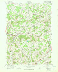
1945 Map of Harpersfield
USGS Topo · Published 1971About this map
Harpersfield and its neighboring hamlets are defined by the high elevations of the Catskill Mountains foothills during the mid-1940s. The landscape is a network of named peaks like Pan Hill, Gunhouse Hill, and Peters Hill, which dictate the winding paths of the Middle Brook and Center Brook. Farming and rural life are centered around crossroads settlements such as North Harpersfield and West Harpersfield, while local education is still anchored in distributed landmarks like School No 5 and School No 6.
Find a feature on this map
37 named features on this map. Tap any name to fly to it.
Don’t see what you’re looking for? This feature index may not catch every label — zoom into the map to look around manually.
Map Details
Editions of this 1945 Harpersfield Map
2 editions found
Other maps of this area

1904 · Richmondville
USGS Topo · 1:62,500

1904 · Hobart
USGS Topo · 1:62,500

1907 · Cooperstown
USGS Topo · 1:62,500

1909 · Cooperstown
USGS Topo · 1:62,500

1909 · Delhi
USGS Topo · 1:62,500

1911 · Delhi
USGS Topo · 1:62,500

1943 · Bloomville
USGS Topo · 1:24,000

1943 · Charlotteville
USGS Topo · 1:24,000
1943 · Schenevus
USGS Topo · 1:24,000

1943 · Summit
USGS Topo · 1:24,000