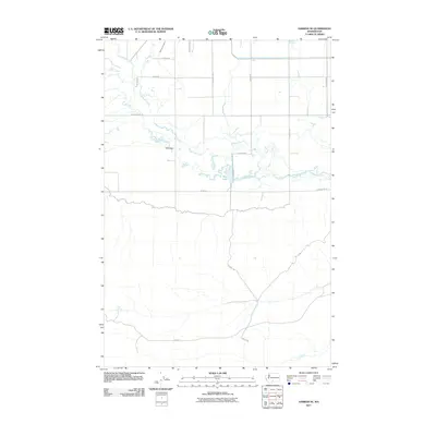
2011 Map of Harrah SE
USGS Topo · Published 2011About this map
Toppenish Creek meanders through the heart of this agricultural landscape in Yakima County, defining the drainage patterns and irrigation infrastructure of the region. The map documents an extensive network of water management features, including the West Island Lateral and East Island Lateral, which support the grid-patterned fields of the valley. Significant landmarks such as Wyna Dam and Mud Lake anchor the central topography, while the northern portion is dominated by well-defined transportation routes like Sunray Rd and Larue Rd. The contrast between the organized irrigation of the lowlands and the more open terrain near Oak Spring and Dry Creek to the south highlights the transition from managed farmland to the natural watercourses of the Washington interior.
Find a feature on this map
21 named features on this map. Tap any name to fly to it.
Don’t see what you’re looking for? This feature index may not catch every label — zoom into the map to look around manually.
Map Details
Editions of this 2011 Harrah SE Map
This is the sole edition of this map. No revisions or reprints were ever made.
Other maps of this area

1910 · Zillah
USGS Topo · 1:125,000

1937 · White Swan
USGS Topo · 1:125,000

1950 · Yakima
USGS Topo · 1:250,000

1958 · Toppenish SW
USGS Topo · 1:24,000

1958 · Toppenish Mtn.
USGS Topo · 1:24,000

1958 · Harrah
USGS Topo · 1:24,000

1958 · White Swan
USGS Topo · 1:24,000

1958 · Harrah SE
USGS Topo · 1:24,000
1958 · Wapato
USGS Topo · 1:24,000

1958 · Yakima
USGS Topo · 1:250,000