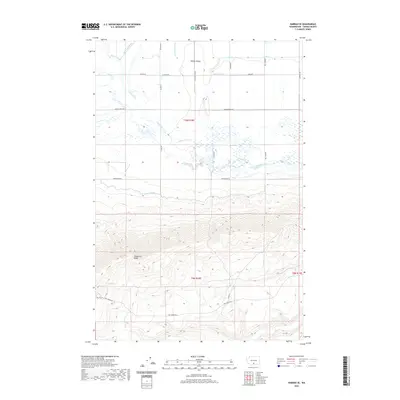
2020 Map of Harrah SE
USGS Topo · Published 2020About this map
The Yakima Valley floor meets the sharp ascent of Toppenish Ridge in this survey of south-central Washington. The northern half of the landscape is defined by an intensive network of irrigation and drainage infrastructure, including the Marion Drain, Unit 2 Canal, and numerous engineered waterways like the E Island Lateral and Piute Lateral. These features support the agricultural character of the region, where roads like Harrah Drain Rd and Lateral C Rd follow the strict cardinal grid of the section lines. To the south, the terrain shifts dramatically as the land rises toward the crest of the ridge. This higher elevation is marked by natural features such as Oak Spring and the winding course of Toppenish Creek, which contrasts with the straight-line geometry of the valley's managed water systems.
Find a feature on this map
31 named features on this map. Tap any name to fly to it.
Don’t see what you’re looking for? This feature index may not catch every label — zoom into the map to look around manually.
Map Details
Editions of this 2020 Harrah SE Map
This is the sole edition of this map. No revisions or reprints were ever made.
Other maps of this area

1910 · Zillah
USGS Topo · 1:125,000

1937 · White Swan
USGS Topo · 1:125,000

1950 · Yakima
USGS Topo · 1:250,000

1958 · Toppenish SW
USGS Topo · 1:24,000

1958 · Toppenish Mtn.
USGS Topo · 1:24,000

1958 · Harrah
USGS Topo · 1:24,000

1958 · White Swan
USGS Topo · 1:24,000

1958 · Harrah SE
USGS Topo · 1:24,000
1958 · Wapato
USGS Topo · 1:24,000

1958 · Yakima
USGS Topo · 1:250,000