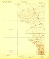
1916 Map of Harrington
USGS Topo · Published 1921About this map
The Southern Pacific (Woodland Line) defines the eastern edge of this landscape, cutting a straight path through the Sacramento Valley floor near the border of Colusa and Yolo Counties. At the center of this agricultural and transit corridor is Harrington, a small settlement positioned directly on the rail line. The map captures a moment of transition between the precisely gridded lowlands to the east and the complex drainage systems of the western foothills. Numerous seasonal watercourses, including Petroleum Creek, Brush Creek, and Buckeye Creek, descend from the western elevations toward the valley. Notably, the western portion of the sheet is labeled as a Preliminary Edition Unsurveyed Area, reflecting the ongoing work of the U.S. Geological Survey and the State of California Department of Engineering to document this terrain during the early 20th century.
Find a feature on this map
9 named features on this map. Tap any name to fly to it.
Don’t see what you’re looking for? This feature index may not catch every label — zoom into the map to look around manually.
Map Details
Editions of this 1916 Harrington Map
3 editions found
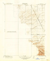
Other maps of this area

1888 · Marysville
USGS Topo · 1:125,000

1891 · Marysville
USGS Topo · 1:125,000

1894 · Marysville
USGS Topo · 1:125,000

1895 · Marysville
USGS Topo · 1:125,000

1905 · Harrington
USGS Topo · 1:24,000

1907 · Dunnigan
USGS Topo · 1:62,500

1907 · Colusa
USGS Topo · 1:62,500

1911 · Grimes
USGS Topo · 1:31,680

1916 · Harrington
USGS Topo · 1:31,680

1916 · Hershey
USGS Topo · 1:31,680