
1916 Map of Harrington
USGS Topo · Published 1947About this map
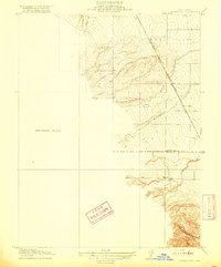
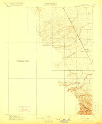
The Southern Pacific (Woodland Line) defines the central corridor of this survey, cutting a straight path through the eastern Sacramento Valley landscape. This specific section, surveyed in 1905, highlights the small rail stop of Harrington, situated along the tracks between several prominent drainage systems. The terrain transitions from the alluvial fans of Petroleum Creek and Brush Creek in the north toward the distinct watercourses of Buckeye Creek and Dunnigan Cr as the land slopes south toward the county boundary. This 1916 edition, later reprinted, documents the early agricultural and industrial infrastructure of the border between Colusa and Yolo counties. The interplay of the railroad and named creeks like Scott Cr suggests a landscape organized around both the transport of valley goods and the seasonal management of water coming off the western hills.
Find a feature on this map
8 named features on this map. Tap any name to fly to it.
Don’t see what you’re looking for? This feature index may not catch every label — zoom into the map to look around manually.
Map Details
Editions of this 1916 Harrington Map
3 editions found
Historical Maps of Harrington Through Time
79 maps found

1904 Sites
Colusa County, CA

1905 Fairview
Colusa County, CA

1905 Harrington
Colusa County, CA

1911 Sanborn Slough
Colusa County, CA
1916 Harrington
Colusa County, CA

1916 Hershey
Colusa County, CA

1917 Compton Landing
Colusa County, CA

1917 Delevan
Colusa County, CA

1917 Sites
Colusa County, CA

1918 Powell Slough
Colusa County, CA

1918 Spring Valley
Colusa County, CA

1920 Venado
Colusa County, CA

1944 Wilbur Springs
Colusa County, CA

1952 Moulton Weir
Colusa County, CA

1952 Sanborn Slough
Colusa County, CA

1953 Cortina Creek
Colusa County, CA

1958 Glascock Mtn
Colusa County, CA

1958 Manor Slough
Colusa County, CA

1958 Sites
Colusa County, CA

1959 Wildwood School
Colusa County, CA

1961 Wilbur Springs
Colusa County, CA

1968 Fouts Springs
Colusa County, CA

1968 Gilmore Peak
Colusa County, CA

1989 Leesville
Colusa County, CA

1989 Salt Canyon
Colusa County, CA

1989 Wilbur Springs
Colusa County, CA

1991 Moulton Weir
Colusa County, CA

1991 Wilbur Springs
Colusa County, CA

1996 Fouts Springs
Colusa County, CA

1996 Gilmore Peak
Colusa County, CA

2012 Cortina Creek
Colusa County, CA

2012 Fouts Springs
Colusa County, CA

2012 Gilmore Peak
Colusa County, CA

2012 Glascock Mountain
Colusa County, CA

2012 Leesville
Colusa County, CA

2012 Manor Slough
Colusa County, CA

2012 Moulton Weir
Colusa County, CA

2012 Salt Canyon
Colusa County, CA

2012 Sanborn Slough
Colusa County, CA

2012 Sites
Colusa County, CA

2012 Wilbur Springs
Colusa County, CA

2012 Wildwood School
Colusa County, CA

2015 Cortina Creek
Colusa County, CA

2015 Fouts Springs
Colusa County, CA

2015 Gilmore Peak
Colusa County, CA

2015 Glascock Mountain
Colusa County, CA

2015 Leesville
Colusa County, CA

2015 Manor Slough
Colusa County, CA

2015 Moulton Weir
Colusa County, CA

2015 Salt Canyon
Colusa County, CA

2015 Sanborn Slough
Colusa County, CA

2015 Sites
Colusa County, CA

2015 Wilbur Springs
Colusa County, CA

2015 Wildwood School
Colusa County, CA

2018 Cortina Creek
Colusa County, CA

2018 Fouts Springs
Colusa County, CA

2018 Gilmore Peak
Colusa County, CA

2018 Glascock Mountain
Colusa County, CA

2018 Leesville
Colusa County, CA

2018 Manor Slough
Colusa County, CA

2018 Moulton Weir
Colusa County, CA

2018 Salt Canyon
Colusa County, CA

2018 Sanborn Slough
Colusa County, CA

2018 Sites
Colusa County, CA

2018 Wilbur Springs
Colusa County, CA

2018 Wildwood School
Colusa County, CA

2021 Cortina Creek
Colusa County, CA

2021 Fouts Springs
Colusa County, CA

2021 Gilmore Peak
Colusa County, CA

2021 Glascock Mountain
Colusa County, CA

2021 Manor Slough
Colusa County, CA

2021 Moulton Weir
Colusa County, CA

2021 Salt Canyon
Colusa County, CA

2021 Sanborn Slough
Colusa County, CA

2021 Sites
Colusa County, CA

2021 Wildwood School
Colusa County, CA

2022 Leesville
Colusa County, CA

2022 Wilbur Springs
Colusa County, CA

2024 Wilbur Springs
Colusa County, CA