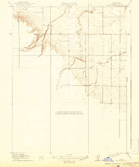
1918 Map of Spring Valley
USGS Topo · Published 1942About this map
Spring Valley occupies a distinctive position in the coastal hills of Colusa County, defined by a complex drainage system that would later see its primary waterway renamed to Cortina Creek. This 1918 edition, based on earlier surveys by E. M. Douglas and C. H. Birdseye, shows a landscape characterized by sharp topographical relief and seasonal watercourses. The network of streams, including Spring Valley Creek and its South Fork, as well as the nearby Old Cortina Creek and South Fork Cortina Creek, reveals how water shaped early settlement and land use in this Mediterranean climate. The detail of Chamisal Creek further illustrates the rugged nature of the western Sacramento Valley foothills during this period of early 20th-century land management.
Find a feature on this map
6 named features on this map. Tap any name to fly to it.
Don’t see what you’re looking for? This feature index may not catch every label — zoom into the map to look around manually.
Map Details
Editions of this 1918 Spring Valley Map
2 editions found
Other maps of this area

1905 · Harrington
USGS Topo · 1:24,000

1905 · Fairview
USGS Topo · 1:24,000

1907 · Colusa
USGS Topo · 1:62,500

1916 · Harrington
USGS Topo · 1:31,680

1918 · Williams
USGS Topo · 1:31,680

1918 · Spring Valley
USGS Topo · 1:31,680
1918 · Arbuckle
USGS Topo · 1:31,680
1918 · Powell Slough
USGS Topo · 1:31,680

1920 · Venado
USGS Topo · 1:62,500

1942 · Colusa
USGS Topo · 1:62,500