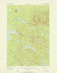
1954 Map of Harrington Lake
USGS Topo · Published 1956About this map
The Penobscot River West Branch carves a deep course through this remote Piscataquis County wilderness, anchored by the massive Ripogenus Dam and its adjacent powerhouse. The 1954 landscape is defined by its complex waterway system, including the expansive Chesuncook Lake and the eight linked Debsconeag Lakes. This survey captures the region as a hub for both logging and early conservation efforts, showing the winding path of the Appalachian Trail as it skirts Rainbow Lake and passes beneath Rainbow Mtn.
Find a feature on this map
134 named features on this map. Tap any name to fly to it.
Don’t see what you’re looking for? This feature index may not catch every label — zoom into the map to look around manually.
Map Details
Editions of this 1954 Harrington Lake Map
5 editions found
Other maps of this area

1927 · Katahdin
USGS Topo · 1:48,000

1930 · Katahdin
USGS Topo · 1:62,500

1949 · Katahdin
USGS Topo · 1:62,500

1951 · Norcross
USGS Topo · 1:62,500

1952 · Jo-Mary Mountain
USGS Topo · 1:62,500

1952 · First Roach Pond
USGS Topo · 1:62,500

1953 · Telos Lake
USGS Topo · 1:62,500

1954 · Chesuncook
USGS Topo · 1:62,500

1954 · Grant Farm
USGS Topo · 1:62,500

1954 · Harrington Lake
USGS Topo · 1:62,500