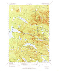
1954 Map of Harrington Lake
USGS Topo · Published 1973About this map
The West Branch Penobscot River serves as the central artery of this Maine wilderness during the mid-1950s, a period when large-scale timber management and hydroelectric infrastructure define the landscape. Engineering landmarks such as the Ripogenus Dam and Chesuncook Dam control the vast waters of Harrington Lake and Chesuncook Lake, facilitating the river's role in industrial logistics. The map documents the presence of a Forest Service Camp and a Lookout Tower atop Soubunge Mtn, signaling active forest fire monitoring and conservation efforts.
Find a feature on this map
133 named features on this map. Tap any name to fly to it.
Don’t see what you’re looking for? This feature index may not catch every label — zoom into the map to look around manually.
Map Details
Editions of this 1954 Harrington Lake Map
5 editions found
Other maps of this area

1927 · Katahdin
USGS Topo · 1:48,000

1930 · Katahdin
USGS Topo · 1:62,500

1949 · Katahdin
USGS Topo · 1:62,500

1951 · Norcross
USGS Topo · 1:62,500

1952 · Jo-Mary Mountain
USGS Topo · 1:62,500

1952 · First Roach Pond
USGS Topo · 1:62,500

1953 · Telos Lake
USGS Topo · 1:62,500

1954 · Chesuncook
USGS Topo · 1:62,500

1954 · Grant Farm
USGS Topo · 1:62,500

1954 · Harrington Lake
USGS Topo · 1:62,500