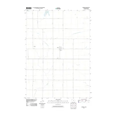
2010 Map of Harris
USGS Topo · Published 2010About this map
The town of Harris serves as the focal point of this Osceola County landscape at the beginning of the 21st century. The map illustrates a strictly gridded agricultural region defined by roads like Vine Ave and Warbler Ave, which facilitate movement through the plains of northwest Iowa and into southern Minnesota. Significant local landmarks include the Harris Post Office and two primary burial sites, Fairview Cemetery and Union Cemetery, which provide essential touchstones for genealogical research in the area. Water management is a defining characteristic of the terrain, as seen in the engineered flow of Judicial Ditch Number 64 and the Judicial Ditch. These man-made channels complement natural drainage systems like the West Branch Little Sioux River, Dugout Creek, and Stony Creek, while Iowa Lake sits along the northern border. The persistence of these watercourses amidst the heavy agricultural grid highlights the ongoing relationship between local hydrology and prairie farming.
Find a feature on this map
25 named features on this map. Tap any name to fly to it.
Don’t see what you’re looking for? This feature index may not catch every label — zoom into the map to look around manually.
Map Details
Editions of this 2010 Harris Map
This is the sole edition of this map. No revisions or reprints were ever made.
Other maps of this area

1954 · Fairmont
USGS Topo · 1:250,000

1958 · Fairmont
USGS Topo · 1:250,000

1960 · Worthington South
USGS Topo · 1:24,000

1960 · Round Lake
USGS Topo · 1:24,000

1960 · Sioux Valley
USGS Topo · 1:24,000

1970 · Lake Park SE
USGS Topo · 1:24,000

1970 · May City
USGS Topo · 1:24,000

1970 · Harris
USGS Topo · 1:24,000
1970 · Lake Park
USGS Topo · 1:24,000

1972 · Ocheyedan
USGS Topo · 1:24,000