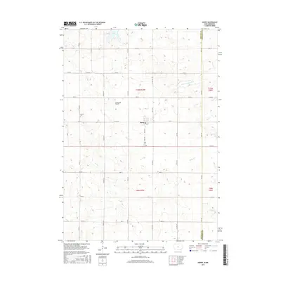
2015 Map of Harris
USGS Topo · Published 2015About this map
Harris serves as the central hub for this portion of Osceola County, situated on the prominent glacial upland known as the Coteau des Prairies. This landform dictates the drainage patterns for the region's numerous waterways, including the headwaters of the W Br Little Sioux River and several smaller streams like Dugout Cr and Stony Cr. The map reveals a strictly organized agricultural landscape defined by a precise section line road grid, with major thoroughfares such as Co HWY a18 and Co RD a22 connecting the rural farmsteads. Local history is anchored by the presence of Fairview Cem and Union Cem, which mark long-established community sites. In the northwest, Iowa Lake straddles the township line, providing a natural break in the expansive prairie terrain.
Find a feature on this map
25 named features on this map. Tap any name to fly to it.
Don’t see what you’re looking for? This feature index may not catch every label — zoom into the map to look around manually.
Map Details
Editions of this 2015 Harris Map
This is the sole edition of this map. No revisions or reprints were ever made.
Other maps of this area

1954 · Fairmont
USGS Topo · 1:250,000

1958 · Fairmont
USGS Topo · 1:250,000

1960 · Worthington South
USGS Topo · 1:24,000

1960 · Round Lake
USGS Topo · 1:24,000

1960 · Sioux Valley
USGS Topo · 1:24,000

1970 · Lake Park SE
USGS Topo · 1:24,000

1970 · May City
USGS Topo · 1:24,000

1970 · Harris
USGS Topo · 1:24,000
1970 · Lake Park
USGS Topo · 1:24,000

1972 · Ocheyedan
USGS Topo · 1:24,000