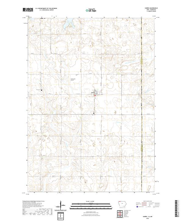
2022 Map of Harris
USGS Topo · Published 2022About this map
The town of Harris sits at the center of this Osceola County landscape, situated upon the high, undulating plateau of the Coteau des Prairies. This distinct upland terrain shapes the local drainage, with water moving through Dry Run and the W Br Little Sioux River toward the south. The map documents a classic Midwestern agricultural grid, where rural life is anchored by historic sites such as Union Cem and Fairview Cem, located just outside the main settlement. To the north, the waters of Iowa Lake straddle the border, serving as a prominent landmark in this prairie region. The layout of county roads, including Co Hwy A18 and Co Hwy M20, illustrates the enduring connectivity of these farming communities, while small waterways like Dugout Cr and Stony Cr weave through the sections.
Find a feature on this map
35 named features on this map. Tap any name to fly to it.
Don’t see what you’re looking for? This feature index may not catch every label — zoom into the map to look around manually.
Map Details
Editions of this 2022 Harris Map
This is the sole edition of this map. No revisions or reprints were ever made.
Other maps of this area

1954 · Fairmont
USGS Topo · 1:250,000

1958 · Fairmont
USGS Topo · 1:250,000

1960 · Worthington South
USGS Topo · 1:24,000

1960 · Round Lake
USGS Topo · 1:24,000

1960 · Sioux Valley
USGS Topo · 1:24,000

1970 · Lake Park SE
USGS Topo · 1:24,000

1970 · May City
USGS Topo · 1:24,000

1970 · Harris
USGS Topo · 1:24,000
1970 · Lake Park
USGS Topo · 1:24,000

1972 · Ocheyedan
USGS Topo · 1:24,000