
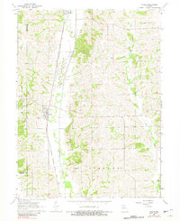
1964 Map of Harris
USGS Topo · Published 1965About this map
Harris and Newtown sit at the center of this rural Sullivan County landscape, where the Chicago Milwaukee St Paul and Pacific railroad forms a distinct north-south artery through the valley. The map documents a classic Midwestern agricultural pattern of the mid-1960s, with scattered homesteads and local landmarks defining the social geography. Small rural centers like Wintersville are detailed alongside numerous family and community landmarks, including the Wintersville Cem and Asbury Ch. Drainage for these rolling fields is provided by Medicine Creek and West Locust Creek, which carve winding paths across the township boundaries of Clay, Liberty, and Medicine. The presence of several small burial grounds, such as Busby Cem and Brackett Cem, provides valuable points of interest for those tracing family history in this corner of North Missouri.
Find a feature on this map
19 named features on this map. Tap any name to fly to it.
Don’t see what you’re looking for? This feature index may not catch every label — zoom into the map to look around manually.
Map Details
Editions of this 1964 Harris Map
2 editions found
Other maps of this area

1946 · Galt
USGS Topo · 1:62,500

1949 · Galt
USGS Topo · 1:62,500

1954 · Centerville
USGS Topo · 1:250,000

1957 · Centerville
USGS Topo · 1:250,000

1958 · Centerville
USGS Topo · 1:250,000

1964 · Pollock NW
USGS Topo · 1:24,000

1964 · Ravanna
USGS Topo · 1:24,000

1964 · Half Rock
USGS Topo · 1:24,000

1964 · Milan West
USGS Topo · 1:24,000
1964 · Pollock SW
USGS Topo · 1:24,000