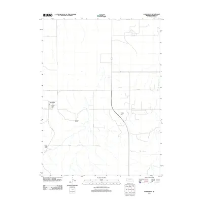
2011 Map of Harrisburg
USGS Topo · Published 2011About this map
Harrisburg serves as the central hub of this High Plains landscape in Banner County, appearing here in the early 21st century as a critical civic anchor. The map highlights key community infrastructure, including the Harrisburg Post Office and the Harrisburg Cemetery, reflecting the long-term settlement patterns of this Nebraska panhandle region. Outside the town center, the terrain is defined by drainage patterns and local landmarks such as Lovers Leap Butte. The presence of the Downer Brothers Dam suggests the importance of water management in this agricultural environment, while a grid of county roads, including Co Rd 35 and Co Rd 20, provides access to the surrounding ranching and farming lands. The inclusion of St Spur 4A demonstrates the primary transportation link connecting this isolated county seat to the broader state highway system.
Find a feature on this map
15 named features on this map. Tap any name to fly to it.
Don’t see what you’re looking for? This feature index may not catch every label — zoom into the map to look around manually.
Map Details
Editions of this 2011 Harrisburg Map
This is the sole edition of this map. No revisions or reprints were ever made.
Other maps of this area

1898 · Scotts Bluff
USGS Topo · 1:125,000

1954 · Scottsbluff
USGS Topo · 1:250,000

1958 · Scottsbluff
USGS Topo · 1:250,000

1973 · Scotts Bluff 4 NW
USGS Topo · 1:24,000

1973 · Kimball 2 NE
USGS Topo · 1:24,000

1973 · Scotts Bluff 4 SE
USGS Topo · 1:24,000

1973 · Scotts Bluff 4 NE
USGS Topo · 1:24,000

1973 · Scotts Bluff 4 SW
USGS Topo · 1:24,000

1973 · Scotts Bluff 3 SE
USGS Topo · 1:24,000

1973 · Kimball 1 NE
USGS Topo · 1:24,000