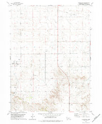
1979 Map of Harrisburg
USGS Topo · Published 1979About this map
Harrisburg serves as the focal point of this high plains landscape, situated near the western edge of the quadrangle. The town's grid is small and orderly, set against a backdrop of extensive ranching and energy extraction. To the south, the Harrisburg Cem provides a quiet record of the area's pioneer families and early residents. The terrain is defined by dramatic changes in elevation, most notably at the prominent Lovers Leap Butte, which overlooks the surrounding basin. Economic activity is clearly marked by a widespread Oil Field and numerous scattered Oil Wells, illustrating the mid-to-late 20th-century reliance on petroleum resources in Banner County. A few Gravel Pits and various other Wells suggest the industrial and agricultural needs of the high desert environment during this era of rural development.
Find a feature on this map
10 named features on this map. Tap any name to fly to it.
Don’t see what you’re looking for? This feature index may not catch every label — zoom into the map to look around manually.
Map Details
Editions of this 1979 Harrisburg Map
This is the sole edition of this map. No revisions or reprints were ever made.
Other maps of this area

1898 · Scotts Bluff
USGS Topo · 1:125,000

1954 · Scottsbluff
USGS Topo · 1:250,000

1958 · Scottsbluff
USGS Topo · 1:250,000

1973 · Scotts Bluff 4 NW
USGS Topo · 1:24,000

1973 · Kimball 2 NE
USGS Topo · 1:24,000

1973 · Scotts Bluff 4 SE
USGS Topo · 1:24,000

1973 · Scotts Bluff 4 NE
USGS Topo · 1:24,000

1973 · Scotts Bluff 4 SW
USGS Topo · 1:24,000

1973 · Scotts Bluff 3 SE
USGS Topo · 1:24,000

1973 · Kimball 1 NE
USGS Topo · 1:24,000