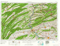
1964 Map of Harrisburg
USGS Topo · Published 1964About this map
Harrisburg sits at the heart of this mid-century Pennsylvania corridor, where the Susquehanna River cuts through the ridges of the Appalachian Mountains. The landscape is defined by the sharp parallel lines of the Allegheny Mountains, including Peters Mountain and Blue Mountain, which separate fertile valleys from dense woodlands like the Bald Eagle State Forest. This era shows a heavily industrialized and militarized region, anchored by the massive Indiantown Gap Military Reservation and logistics hubs like the Naval Supply Depot and Letterkenny Ordnance Depot.
Find a feature on this map
131 named features on this map. Tap any name to fly to it.
Don’t see what you’re looking for? This feature index may not catch every label — zoom into the map to look around manually.
Map Details
Editions of this 1964 Harrisburg Map
This is the sole edition of this map. No revisions or reprints were ever made.
Other maps of this area

1889 · Catawissa
USGS Topo · 1:62,500

1889 · Hazleton
USGS Topo · 1:62,500

1889 · Pottsville
USGS Topo · 1:62,500

1891 · Wilkesbarre
USGS Topo · 1:62,500

1891 · Hazleton
USGS Topo · 1:62,500

1891 · Pottsville
USGS Topo · 1:62,500

1891 · Lebanon
USGS Topo · 1:62,500

1892 · Catawissa
USGS Topo · 1:62,500

1892 · Lykens
USGS Topo · 1:62,500

1892 · Hummelstown
USGS Topo · 1:62,500