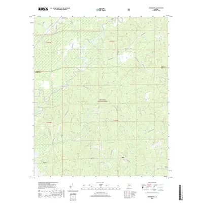
2018 Map of Harrisburg
USGS Topo · Published 2018About this map
Harrisburg and the surrounding woodlands of the Talladega National Forest define this 2018 study of the Bibb County and Perry County border. The landscape is characterized by the winding path of the Cahaba River and its numerous tributaries, including Potato Patch Cr and Mill Cr. Family and community history is preserved through several rural burial grounds such as Perkins Cem, Paynes Cem, and Stewart Cem, alongside the Mount Gilead Cem. The map illustrates a region where small settlements like Abercrombie and Adler are connected by a network of timber and forest roads like Fire Tower Rd and Harrisburg Rd, reflecting a landscape dedicated to conservation and forestry. Notable landforms such as James Bottom and Hickory Hollow provide specific geographical context for local genealogists and researchers tracking land ownership and traditional place names.
Find a feature on this map
40 named features on this map. Tap any name to fly to it.
Don’t see what you’re looking for? This feature index may not catch every label — zoom into the map to look around manually.
Map Details
Editions of this 2018 Harrisburg Map
This is the sole edition of this map. No revisions or reprints were ever made.
Other maps of this area

1953 · Montgomery
USGS Topo · 1:250,000

1956 · Montgomery
USGS Topo · 1:250,000

1957 · Montgomery
USGS Topo · 1:250,000

1959 · Summerfield
USGS Topo · 1:62,500

1979 · Marion North
USGS Topo · 1:24,000

1979 · Harrisburg
USGS Topo · 1:24,000

1979 · Pondville
USGS Topo · 1:24,000
1980 · Centreville East
USGS Topo · 1:24,000
1980 · Centreville West
USGS Topo · 1:24,000
1980 · Oakmulgee
USGS Topo · 1:24,000