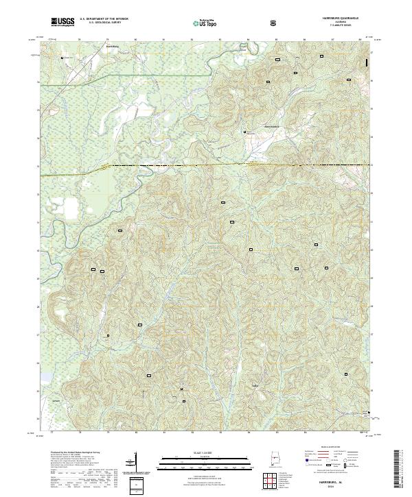
2024 Map of Harrisburg
USGS Topo · Published 2024About this map
Talladega National Forest dominates the terrain of this West Central Alabama survey, where the Cahaba River winds through the northern reaches near Harrisburg. The landscape is a network of small drainage basins, defined by watercourses like Potato Patch Creek, Mill Creek, and Blue Girth Creek. Settlement patterns are sparse and rural, focused around crossroads and family landmarks such as Abercrombie and Levert. For those researching local families, the map identifies several burial sites, including Perkins Cem in the northwest and Mount Gilead Cem near the Bibb and Perry County line. The topography is characterized by intricate hollows and bottoms, most notably James Bottom and Hickory Hollow, illustrating the complex drainage systems that feed into the river valley.
Find a feature on this map
39 named features on this map. Tap any name to fly to it.
Don’t see what you’re looking for? This feature index may not catch every label — zoom into the map to look around manually.
Map Details
Editions of this 2024 Harrisburg Map
This is the sole edition of this map. No revisions or reprints were ever made.
Other maps of this area

1953 · Montgomery
USGS Topo · 1:250,000

1956 · Montgomery
USGS Topo · 1:250,000

1957 · Montgomery
USGS Topo · 1:250,000

1959 · Summerfield
USGS Topo · 1:62,500

1979 · Marion North
USGS Topo · 1:24,000

1979 · Harrisburg
USGS Topo · 1:24,000

1979 · Pondville
USGS Topo · 1:24,000
1980 · Centreville East
USGS Topo · 1:24,000
1980 · Centreville West
USGS Topo · 1:24,000
1980 · Oakmulgee
USGS Topo · 1:24,000