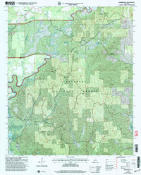
2002 Map of Harrisburg
USGS Topo · Published 2003About this map
The Cahaba River winds through the heart of this landscape, marking the rugged transition between Harrisburg and the dense timberlands of the Talladega National Forest. In the early 21st century, this section of Perry County remained defined by its rural church communities and historic creek crossings. Family history is etched into the terrain at Perkins Cem and Mt Gilead Cem, while local landmarks like the Cahaba Lookout and Ham Fork Hunter Camp indicate the area's use for both forestry management and recreation. The northern reaches show a cluster of activity around the Antioch Ch and the Harrisburg Bridge, where Affonee Creek joins the main river channel. Further south, the map details smaller settlements like Levert and the drainage patterns of Potato Patch Creek and Mill Creek.
Find a feature on this map
23 named features on this map. Tap any name to fly to it.
Don’t see what you’re looking for? This feature index may not catch every label — zoom into the map to look around manually.
Map Details
Editions of this 2002 Harrisburg Map
This is the sole edition of this map. No revisions or reprints were ever made.
Other maps of this area

1953 · Montgomery
USGS Topo · 1:250,000

1956 · Montgomery
USGS Topo · 1:250,000

1957 · Montgomery
USGS Topo · 1:250,000

1959 · Summerfield
USGS Topo · 1:62,500

1979 · Marion North
USGS Topo · 1:24,000

1979 · Harrisburg
USGS Topo · 1:24,000

1979 · Pondville
USGS Topo · 1:24,000
1980 · Centreville East
USGS Topo · 1:24,000
1980 · Centreville West
USGS Topo · 1:24,000
1980 · Oakmulgee
USGS Topo · 1:24,000