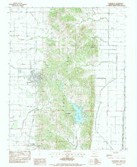
1983 Map of Harrisburg
USGS Topo · Published 1984About this map
Crowleys Ridge dominates this landscape, rising above the flat alluvial plains and directing the flow of waterways like Bolivar Creek and Holly Springs Branch. The city of Harrisburg serves as a focal point along the western edge of the ridge, where the Missouri Pacific railroad line runs parallel to the elevation change. This corridor reflects the historical importance of rail in connecting the agricultural interior of Poinsett County to broader markets.
Find a feature on this map
33 named features on this map. Tap any name to fly to it.
Don’t see what you’re looking for? This feature index may not catch every label — zoom into the map to look around manually.
Map Details
Editions of this 1983 Harrisburg Map
This is the sole edition of this map. No revisions or reprints were ever made.
Other maps of this area

1939 · Vanndale
USGS Topo · 1:62,500

1939 · Weiner
USGS Topo · 1:62,500

1940 · Princedale
USGS Topo · 1:62,500

1940 · Dee
USGS Topo · 1:62,500

1953 · Memphis
USGS Topo · 1:250,000

1956 · Memphis
USGS Topo · 1:250,000

1956 · Princedale
USGS Topo · 1:62,500

1958 · Dee
USGS Topo · 1:62,500

1958 · Vanndale
USGS Topo · 1:62,500

1959 · Weiner
USGS Topo · 1:62,500