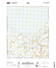
2017 Map of Harrison Bay B-1 NE
USGS Topo · Published 2017About this map
Harrison Bay and the intricate, water-logged shoreline of the North Slope are the primary focus of this late-edition topographic study. The landscape is dominated by the delta-like reach of Kalubik Creek, which meanders through a dense network of thaw lakes and coastal wetlands before meeting the Beaufort Sea. The map's surveyed sections, including t13n r7e and t13n r8e, illustrate the modern township and range grid as it is applied to this dynamic Arctic environment. This 2017 survey reflects the contemporary hydrology and coastal indentation of the region, providing a high-resolution look at the shifting boundary between the Alaskan tundra and the sea.
Find a feature on this map
6 named features on this map. Tap any name to fly to it.
Don’t see what you’re looking for? This feature index may not catch every label — zoom into the map to look around manually.
Map Details
Editions of this 2017 Harrison Bay B-1 NE Map
This is the sole edition of this map. No revisions or reprints were ever made.
Other maps of this area

1951 · Harrison Bay
USGS Topo · 1:250,000

1951 · Beechey Point
USGS Topo · 1:250,000

1955 · Harrison Bay
USGS Topo · 1:250,000

1955 · Beechey Point
USGS Topo · 1:250,000

1955 · Harrison Bay C-1
USGS Topo · 1:63,360

1955 · Harrison Bay B-1
USGS Topo · 1:63,360
1955 · Beechey Point C-5
USGS Topo · 1:63,360

1955 · Beechey Point B-5
USGS Topo · 1:63,360

1960 · Beechey Point
USGS Topo · 1:250,000
1962 · Harrison Bay B-1
USGS Topo · 1:50,000