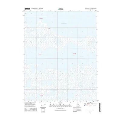
2016 Map of Harrison Bay C-4 SW
USGS Topo · Published 2016About this map
Comfort Point marks a distinct geographic protrusion into the southern waters of Harrison Bay on Alaska's northern coast. The landscape is defined by the sinuous path of the Kogru River, which meanders through a complex network of coastal wetlands and ephemeral thaw lakes. This 2016 survey provides a precise view of the interface between the Arctic shoreline and the inland tundra within the North Slope Borough. The lack of infrastructure or permanent settlements reflects the preservation of a traditional subsistence environment, where the shifting hydrology of the river delta and the bay remains the primary force shaping the terrain. Surveyed township boundaries from t15n r2w through t13n r1w provide a grid for researchers and land managers monitoring this remote coastal stretch.
Find a feature on this map
8 named features on this map. Tap any name to fly to it.
Don’t see what you’re looking for? This feature index may not catch every label — zoom into the map to look around manually.
Map Details
Editions of this 2016 Harrison Bay C-4 SW Map
This is the sole edition of this map. No revisions or reprints were ever made.
Other maps of this area

1951 · Harrison Bay
USGS Topo · 1:250,000

1955 · Harrison Bay
USGS Topo · 1:250,000

1955 · Harrison Bay C-5
USGS Topo · 1:63,360

1955 · Harrison Bay B-5
USGS Topo · 1:63,360

1955 · Harrison Bay C-4
USGS Topo · 1:63,360

1955 · Harrison Bay B-4
USGS Topo · 1:63,360

1962 · Harrison Bay C-5
USGS Topo · 1:50,000
2013 · Harrison Bay B-5 NE
USGS Topo · 1:25,000
2013 · Harrison Bay B-4 NW
USGS Topo · 1:25,000
2016 · Harrison Bay C-4 SE
USGS Topo · 1:25,000