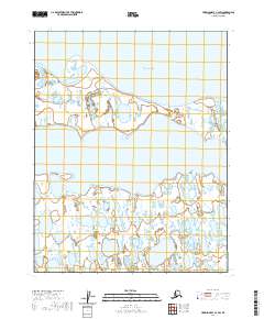
2020 Map of Harrison Bay C-4 SW
USGS Topo · Published 2020About this map
The vast, low-lying coastal plains of the North Slope meet the Arctic waters of Harrison Bay in this contemporary record of the Alaskan wilderness. The landscape is defined by the sinuous path of the Kogru River, which winds through a dense network of thaw lakes and wetlands before emptying into the bay. At the northern edge of the shoreline, Comfort Point serves as a distinct geographic landmark on the edge of the Beaufort Sea. The map reveals the intricate hydrology typical of the Arctic coastal plain, where the shifting boundaries between water and land are governed by seasonal cycles and permafrost dynamics. This 2020 survey provides a high-resolution look at a remote environment where natural features like the river's delta and the coastal spit remain the primary points of orientation in an area devoid of permanent human infrastructure.
Find a feature on this map
8 named features on this map. Tap any name to fly to it.
Don’t see what you’re looking for? This feature index may not catch every label — zoom into the map to look around manually.
Map Details
Editions of this 2020 Harrison Bay C-4 SW Map
This is the sole edition of this map. No revisions or reprints were ever made.
Other maps of this area

1951 · Harrison Bay
USGS Topo · 1:250,000

1955 · Harrison Bay
USGS Topo · 1:250,000

1955 · Harrison Bay C-5
USGS Topo · 1:63,360

1955 · Harrison Bay B-5
USGS Topo · 1:63,360

1955 · Harrison Bay C-4
USGS Topo · 1:63,360

1955 · Harrison Bay B-4
USGS Topo · 1:63,360

1962 · Harrison Bay C-5
USGS Topo · 1:50,000
2013 · Harrison Bay B-5 NE
USGS Topo · 1:25,000
2013 · Harrison Bay B-4 NW
USGS Topo · 1:25,000
2016 · Harrison Bay C-4 SE
USGS Topo · 1:25,000